I&M Canal

Strategerie Follow-Up by Erin Wade

I posted last time about my efforts to find a way to ride that wouldn’t put me out on the road in the deafening wind of late February. I had a primary plan of heading down to the I&M Canal Trailhead in LaSalle, with a backup plan of just going into town and riding around the all-too familiar streets of my childhood home.

I’d formulated the backup plan because I really didn’t have a clear idea of what the conditions would be like on the Canal Trail. This has been a struggle both with respect to finding out current conditions, and how the trail is managed for the winter and snow in general. Viz: do they clear the trail, do they groom it for skiing, do they let snowmobiles use it? What’s the story?

I’ve tried asking after this on social media in the past, but the extensive nature of the trail makes it difficult to sort out - it appears that different areas may manage their sections of the trail differently, so sorting out an answer for the area of one’s own specific interest can be challenging.

You know - unless you actually go and look at it. This has been on my list for some time - the last several years, to be honest. But the trailhead is a half-hour away, and there are usually other things to do (like riding out of my own driveway) to compete with the investigation.

I figured this was going to finally be my opportunity to find out.

Let’s get the good news out of the way: I didn’t have to resort to Plan B.

When I got the trailhead it was clear that the low-lying nature of the canal and the woodlands around it were helping to avoid or screen out most of the wind that I had been contending with on the open prairie. This was sort of a bonus - I thought that might be the case, but I wasn’t really sure it would turn out to be.

The trail itself turned out to be an interesting mix of surfaces. A couple of days of above-freezing temps had melted the snow away in the more open spots…

Open Asphalt

…while the shady areas retained more coverage.

Residual white stuff.

I also quickly got my answer to how the trail is managed for winter use:

I can see why you’d want to mark this as a danger spot…

In addition to the hazard marker there were also “curve ahead” signs on a couple of sections of the trail further down. I’m a little ashamed to admit that at first I found these a bit odd - I mean, what cyclist rides so fast on these trails that they need a curve warning? - before I realized that they were for the snowmobiles.

The snowy sections made it clear that, despite the signs for the powered sleds, there is quite a bit of mixed use of the trail. There were lots of footprints, dog tracks, and at least one extended section of cross-country ski markings. So: it would appear that this section of the trail, at least, is not cleared, nor is it groomed for skiing. All of which is well enough - I have no objection to snowmobiling, and in fact spent a fair portion of my youth sliding around the winter countryside on an Artic Cat Lynx my own darn self. But it means that you’d likely need a fat bike or trike to tackle it when there’s been a sizable deposit of the white stuff (and I do not currently have such a machine in my stable).

But none of that applied to this ride. The snow-covered sections were not so deep that they couldn’t be managed by my mostly stock Catrike Expedition with her road tires, so I was all good on that front.

I did become acutely aware of a couple of things as the ride progressed, however. First, I was thankful for the presence of my fenders for, oh, say, the thousandth time, as temperatures in the mid- to high-40°’s conspired with the snow to allow for a lot of standing water along the trail. I also found that, while my rear fender does prevent that telltale cycling mud-stripe from appearing on your back, it is still possible for your posterior to become soaked under the right circumstances.

It was also clear that I had hit the trail on perhaps exactly the right day. Where the snow had mostly melted away the ground was soft underneath. But, thankfully, the thaw had thus far only affected the first inch or so of topsoil. This meant that, while it was slow going in some spots, there was none of the deep mud suck that can happen after several days of spring warming. It took me a little bit to figure out, but it turned out it was a little better to ride thru the wetter sections of the trail. The standing water was perhaps acting as an insulator, or possibly was just a sign that the ground underneath hadn’t warmed enough to absorb the water, but either way it was typically more solid that the stuff free of moisture. I’m pretty sure it sections would be very challenging with another day or two of temperatures above the freezing mark.

Valencia at New Bridge (that’s my name for it - I don’t know if it has an official name…)

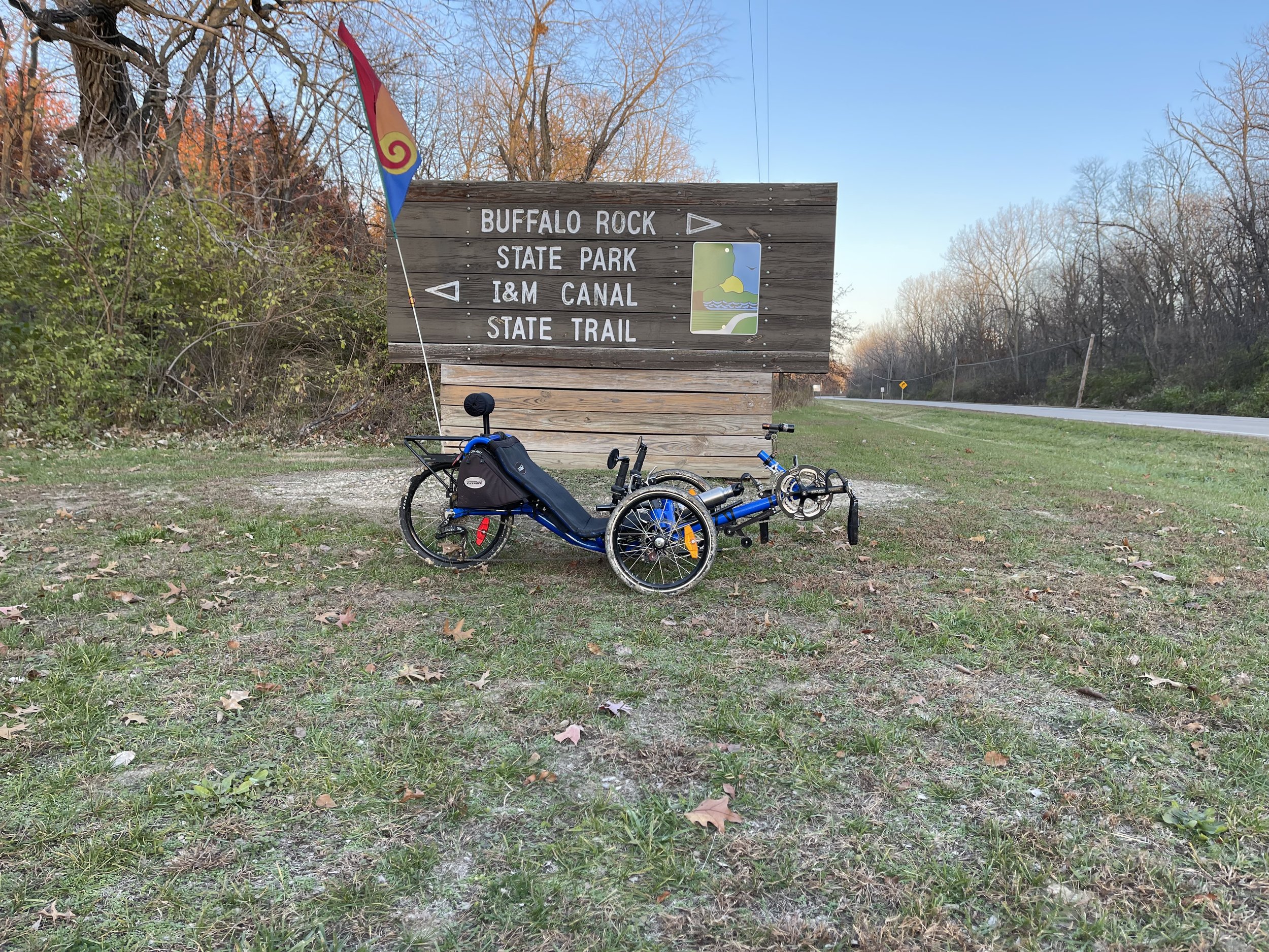
I decided to stop at the new bridge over the former rustic creek crossing. This spot is a little over seven miles in, and so made for about a 14-mile round trip. This fit nicely with the time I had allotted for the ride, and if I’m being honest, as wet as it was, I did not want to contend with the clay-soup sections that lie between the bridge and Buffalo Rock State Park.

As it was, my orange girl collected a fair amount of trail residue along the way…

Dirt from the expedition on my Expedition.

…but that’s a good thing in the grand scheme of things, because the dirt means I got to ride. And all in all, it was a good ride. A few more days of thaw and it would have been considerably less pleasant - soft, slow, and messy - but then that’s a reality of both the big canal trails here in northern Illinois. But I was able to luck in on a good moment this time around.

Soft

I & M Canal Trail - Rusticness Revised by Erin Wade

The I&M Canal Trail runs from LaSalle, Illinois up towards Lake Michigan covering much of the northeastern area of the state in fits and starts. The trail head in LaSalle is relatively close by for me, and as such I’ve ridden it several times, with my longest outing thus far taking me from LaSalle to Ottawa and back, in part to obtain libations from Tangled Roots brewery.

Long sections of the trail on this route could euphemistically be described as rustic - while there are a few paved sections of the trail over this distance, most of it is dirt, and it can be challenging in places during the wetter seasons. But by far the most rustic portion of the trail has been this section:

Ford the mighty river

What you see in this picture is an honest-to-goodness water crossing. There is no formal bridge - someone has been kind enough to provide a narrow wooden causeway that simply lays across the stream bed, with ropes tethering it to trees to keep the current from simply carrying it away. In my experience with this section the causeway was in a different position each time. And, crucial for my purposes, it isn’t wide enough for all three wheels of the trike.

Not sure it’s gonna fit…

I’ve always had to carry the trike across. From my perspective this has always just been a part of the deal, but I am sure there are people who have arrived at this point and just decided that is the end of the trail for them. Understandably so.

However, the Canal Organization had put up a post indicating that the “washout between Utica and Ottawa” had been repaired. I assumed this was referring to the same spot. It was difficult to tell, however, because the picture that accompanied the post bore little resemblance to my recollection of how the area looked. Also, the word “washout” implied that there had been some sort of bridge (or maybe a culvert?) there before, and there was little about the appearance of the place that suggested it had ever been anything but open water.

In short: I wanted to see for myself if it was fixed.

I set out for a ride from the LaSalle trailhead to Buffalo Rock State Park, a route I’ve taken several times before. Life sometimes has a way of otherwise intruding on my riding opportunities, so I got started a little later in the day than I’d hoped. I arrived at the trailhead a little before three in the afternoon. With the sun setting around 4:30 this time of year, I knew that it would be getting dark on my way back.

Pro tip: if you are going to be riding at the end of the day, either leave the sunglasses behind, or at least bring along your regular glasses for when it starts to get dark. I myself would never forget to do this, and realize, hypothetically speaking, about four miles in that I had left my regular specs in the car.

Never…

Ahem. Anyway, I soldiered on, reasoning that the time lost riding back would only further ensure that I would be riding in the dark on the way back.

This being mid-November, I largely had even the more popular sections of the trail to myself. I headed out from LaSalle, dodged the potholes on the early portion of the trail, passed through Utica where they now have a bike rental station:

Bicycles for sale or rent… ok - just for rent.

And from there into the more rustic portions of the trail. The Canal National Heritage Area website says that the trail surface between LaSalle and Ottawa is “Part Crushed Limestone, Part Paved”. However, the interested rider should be aware that, in portions of this section, if there was ever crushed limestone laid down it has long since crumbled such that it is both microscopic, and been completely overgrown. Much of the trail between Utica and Buffalo Rock is grass with a single track dirt paths down it - sometimes just one, sometimes one on either side. The shot below is an example of this from May of this year:

Single track - May 2021

This isn’t bad for riding, per se, (though it can get soupy in spots when wet), but it’s likely not what people would expect given the description on the website.

And then I arrived at the crossing:

A bridge not too far

The bridge work completely transforms the area. I know it’s in the same spot, but it’s hard to reconcile the current presentation with what was there before. It takes what was literally a considerable obstacle to overcome and makes it a non-issue. People who are new to the trail will come to this point and likely give no thought to what the bridge is doing for them as they ride across. In fact, it seems likely that I will reach that perspective myself at some point in the future. It does make one appreciate what our ancestors had to contend with - many of the towns and cities in this region are located in part because they were good shipping points for river traffic and crossing points for ferries. All of that went to the wayside once the bridges were built.

The rest of the ride was largely uneventful. I made it to Buffalo Rock State Park - the sometimes treacherous clay soup sections were a little soft, but easily passable.

Of course, the last few miles of the ride were largely in dark, although this offered some views if its own:

Sunset on the canal

The interesting part of that shot to me is that it’s much lighter than what I was seeing. I knew, when I would look over top my sunglasses, that it wasn’t quite as dark as it seemed. Still, relative degree of light is just about all I can see without my glasses, so the sunglasses stayed on. But with lights in place and some careful riding, I was able to make it back to the LaSalle trail head without issue.

With the new bridge in place the trip along this section of trail will be much easier and more accessible to riders. And it makes the I&M Canal portion of the Rails to Trails coast-coast trail seem one step closer to being more feasible. It’s a win all around.