trails

Rockford Bicycle Company to Rock Cut State Park - Trail Review by Erin Wade

Happenstances of life put me in the Rockford area this past weekend on an unusually nice November day. Prior to moving back out to our Homestead we had lived in Rockford for a solid 17 years. In many ways the area, with its prominent park and bike trail system, as well as the presence of Rock Cut State Park at the north end of the city, reinvigorated my enjoyment of cycling after leaving college.

When we moved our engagement with the city continued due to family, work, and our child’s engagement in competitive gymnastics with a program situated there. And given those factors, I would continue to periodically bring along my machine. In these latter events, I would typically ride the path from Rockford Bicycle Company into Rock Cut State Park, around the park, and back again. This is a 12-mile loop that offers a bit of hill climbing both up into the park, and along the park road, as well as both urban, woodland, and lake views. In many ways, Rock Cut is a jewel.

Still, it had been several years since I’d ridden the trail. It’s become derigeur to blame such things on the pandemic, but that’s not the case here. Looking into Cyclemeter, my last foray on it was in August of 2018, well before any restrictions went into place; and the time before that had been nearly an entire year before - August 2017. As soon as I started looking up those dates I remembered why - in my notes for the 2017 ride on the trail I wrote, simply: “the condition of both the trail and the road around Rock Cut really, really sucks”. The asphalt trail itself was punctuated by a multitude of frost heaves and cracks, and the ring road around the park itself was full of potholes. It had reached the point where traversing the trail delivered a substantial beating to the rider.

But all of that was over three years ago, so it seemed reasonable to investigate whether there had been any improvements. And besides, I’d never ridden the trail on my Expedition - my last attempt was nearly a year before getting my Atomic Orange machine.

Valencia @ RBC

Valencia @ RBC

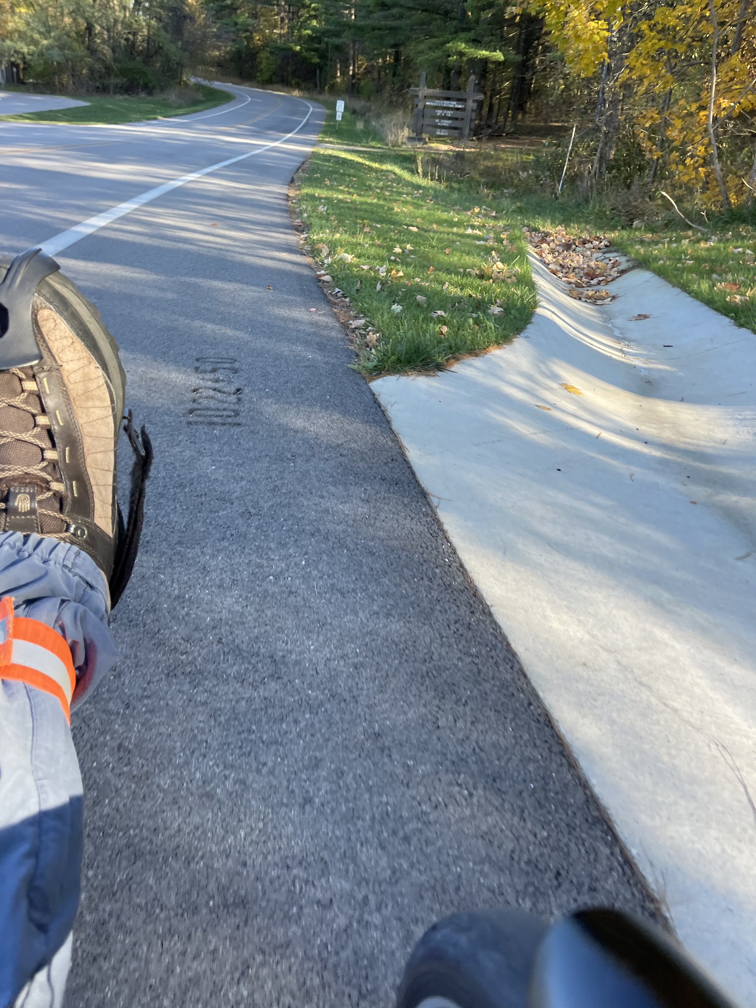
I’m glad I did. As soon as I pulled up to the parking lot at Rockford Bicycle Company I could see that the path itself looked to have a relatively fresh layer of asphalt on it. A quick Google Search suggests that this is a very recent change, with the work apparently having been done last month. It certainly looks very new:

Fresh Asphalt

Fresh Asphalt

And it rides much, much better. The new layer of surface also included improvements where the path connected to the couple of bridges along the way - this was often a jarring transition in the past. And this gave me optimism for the route overall, but I kept that optimism guarded - the Perryville path and the state park are governed by different entities. The improvements here did not necessarily mean that things would be better once I got into the park itself.

I mulled this as I rode along Perryville Road. This first 2 1/2 miles of the trail is the urban portion. It is situated alongside, and mirrors, Perryville road, which is a heavily traveled four lane roadway. This section involves crossing four separate intersections (in each direction), three of which are fairly busy and governed by traffic lights. This has always been my least favorite part of the ride, and is probably the biggest downside to the path itself: The crossing are situated at the intersections, which is probably not ideal, but the path was added after the roadways were built. One wants to be alert to the traffic patterns during these crossings.

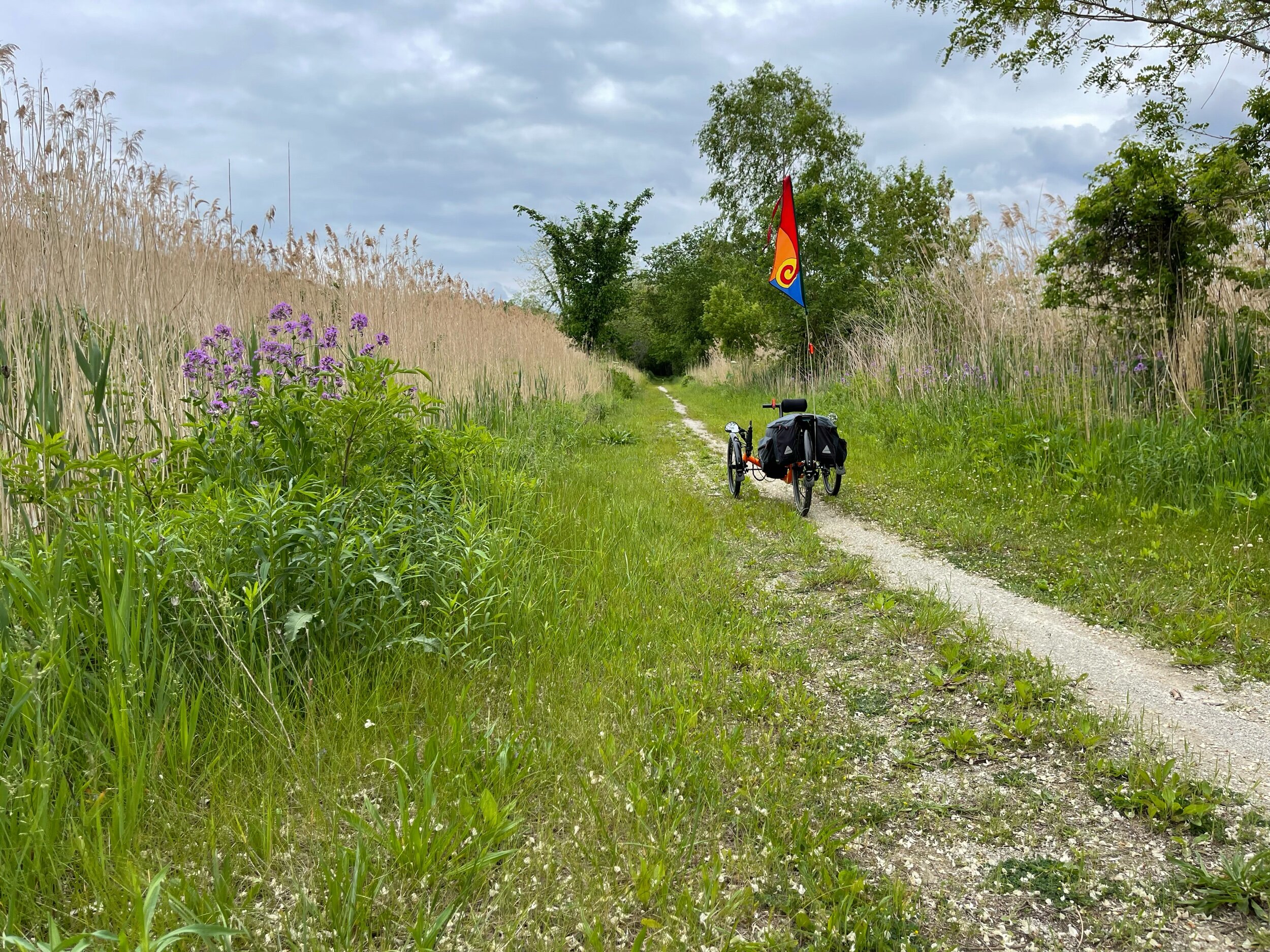
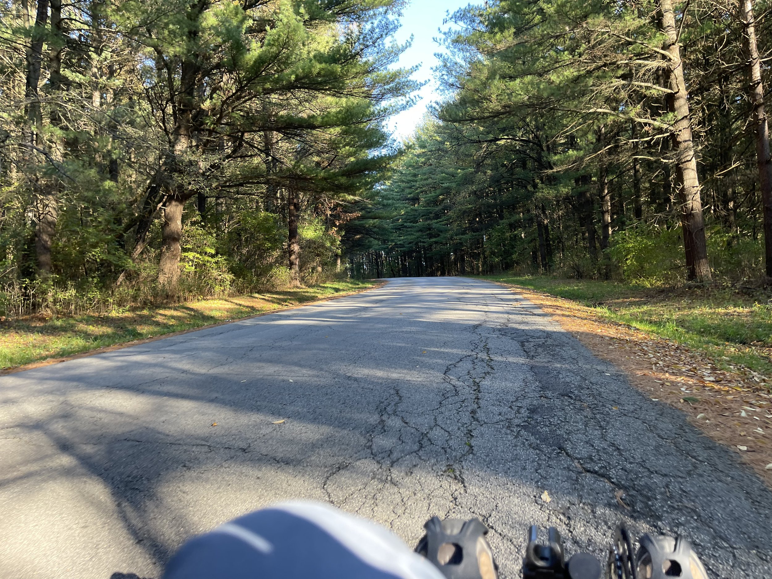
Getting past that, however, rewards with entry into the winding, tree covered section of the path that parallels Willow Creek up into Rock Cut.

Winding through the trees

Winding through the trees

Winding thru the trees

Winding thru the trees

This is a hill climb - you are riding up the path as Willow Creek falls. How much of a climb depends upon your experience, of course. It gets steeper as you go, and there is no real way to build up speed going into it - it’s all climb on this part - so it’s a challenge for the newer or less experienced hill rider. But getting to the top yields the entrance into Rock Cut:

Valencia @ Rock Cut

Valencia @ Rock Cut

Once crested the hill and could see into the park I could see that there had been improvements. Immediately it was clear that the bridge across the spillway had been replaced (you can see it in the background in the picture above). The old bridge had a wooden roadway with steel bands for vehicle wheel support stretched across it - the new one is an entirely concrete affair. I could also see to the north that some sort of sidewalk had been added along the roadway.

I started across the bridge to follow the road loop around Pierce Lake. The road here has been re-surfaced, and is much improved. I could see also that there is a new, paved bike path off the road that circles closer to the lake. I was interested in following my old route, so I didn’t explore that path, though I would later see that it came out near the concessions and boat ramp.

What I found about the roadway itself was a somewhat …mixed bag. The road was new following the bridge, but seemed less so shortly afterward. Then, as I came down the hill towards the concessions and boat ramp, I discovered another new section of roadway onto which a bike lane had been added! It just sort of appeared there, following that downward section.

Sudden Bike Lane

Sudden Bike Lane

I shifted over to the bike land and proceeded, only to find another 3/4 of a mile or so later (I am estimating) that it just disappeared as the road returned to older surfacing.

Not everything old is new again

Not everything old is new again

The bike lane reappeared again on the south side of the lake.

It’s back!

It’s back!

It doesn’t take much extrapolation to figure out that the park is getting its improvements piecemeal (these done in 2019, according to these plans) . What is notable is that they clearly did focus their initial efforts on what were the absolute worst parts of the roadway around the park. While not all of the surfaces were new, and I did have to steer around some cracks in the older surfaces, I did not have to engage in the rampant dodging of potholes that I recall from my rides in 2017 and 2018. And, while it was very nice to have that dedicated bike lane where it appeared, traffic around the park is governed at a very slow limit (20 mph, I believe), and even with the hills and curves, most sight lines are fairly clear. If you are comfortable riding on the road in general, you will be comfortable here, with or without the dedicated lane.

The hills around the park road do mostly have lead-ins to the uphill sections, so you will mostly have an opportunity to gather speed going into them. The loop around the park itself is a little over four miles, bringing you back to the top of Willow Creek.

From Willow Creek it’s downhill all the way back to Perryville Road. It isn’t a downhill free-for-all though. The path is fairly heavily used, and the winding and twisting nature of it through the trees means that suddenly encountering others is an imminent event - you have to moderate your speed here (my fastest speeds were on the downhill road sections within the park). But given the woodland scenery, it’s hardly a sacrifice to set aside a bit of the downhill speed.

The rest, is, of course, just a reverse of the beginning of the ride. For my part, I found that the Expedition handled the route quite well. I was able to maintain speeds here above my prior rides on my Catrike Pocket, which I wasn’t sure would be the case, as the 20” rear wheel on the Pocket might have given it the advantage. In the end, I was on par with my times on my old Cannondale, tho this might simply owe to the fact that I’m riding a lot more than I was back then.

I had put off writing about this route back in 2017 and 2018 because I really did not feel I could recommend it back then - the poor road surfaces really made it an unpleasant ride. That has changed, now, with the improvements noted here. The new surfaces are wonderful, and within the park itself they appear to have made good choices about where to put their efforts - the older surfaces, where they remain, are good enough to allow for a decent ride.

I can’t recommend this ride as a destination, per se. It’s too short, and too much of it involves paralleling a major roadway to suggest that anyone travel just to ride on it. But if you are traveling out towards Rockford anyway, and are looking for a place to ride, I think this route offers a good reason to bring your cycling machine along.

I’ll note also that it appears that there are plans underway to extend the Perryville path up into the town of Roscoe and connect it to the Stone Bridge Trail. It looks like that’s likely a couple of years out yet, but if/when finished would connect it to a couple of the rail-trail systems in the area, heading out into more rural areas. For folks who are interested, it may be worth it to check back on that.

I&M Canal Trail - Brandon Road Lock & Dam by Erin Wade

At over 80 miles in length, the I&M Canal Trail offers a lot of territory to explore here in Northern Illinois. For myself, I’ve ridden various distances across the western section of the trail, between LaSalle and Ottawa, finally getting the opportunity to ride the entire distance between the two cities this spring.

The trailhead in LaSalle is only about a half-hour from home, which makes it an attractive starting point for a rider who mostly just takes out of his driveway. But, as sometimes happens, I had to travel eastward for other purposes, so I took the trike along in case the opportunity for a ride presented.

As luck would have it, the opportunity was quite cooperative, and I found myself in the vicinity of the Brandon Road Lock and Dam entrance to the canal trail. This point of trail access is sited in the comparatively tiny town of Rockdale, just south of Joliet. I’d never been to this particular part of the trail or, frankly even heard of Rockdale, so I wasn’t sure what to expect. What I found was what felt like a somewhat remote industrial area. When I saw the small parking lot it helped that I knew what I was looking for, because it was immediately obvious that there was a canal there until I opened the door of the car and heard the water rushing.

And it does rush here, which is not true everywhere along the canal. There are several miles of the canal in other portions where the waterway itself has since silted in. In those portions you can usually - but not always - tell where the canal used to be, but only because you know that it used to be there. It makes you a little more aware that Mother Nature did not intend for this waterway to be present and, without human intervention, she has a tendency to put things aright as she sees they should be.


Enjoying this post? Check out our Cycling page for links to other cycling articles on Applied Life


But that’s not the case at the Brandon Road site. In fact, tho I didn’t notice it before I started out - in too big a hurry to just get riding, I think - there’s a spillway of sorts right at this site (perhaps part of the system for the newer canal that replaced the I&M) that accounts for all of the rushing sound. And this all means that, for this section of the trail you are afforded the sort of views that come with riding along the water:

Wetland

Wetland

It also offers up the type of wetland wildlife you might expect. Probably my favorite sight was the Snowy Egret (I think - it was white and heron shaped) that I saw both in flight and standing on the bank. It was shy of the camera (or perhaps I was just too slow and clumsy to capture it), so I wasn’t able to capture its image. But I did see plenty of these guys:

Gooseflesh

Gooseflesh

Gooseflesh

Gooseflesh

I came across them in a large flock within the first half-mile or so of the ride. I figured they would simply peel off into the water as I approached.

They did not. In fact, what they chose to do was run away from me, straight down the trail in the same direction of travel. I slowed down so as not to catch up with them - I am well aware that a goose can be a large batch of unpleasantness if it wants to be, and further aware that I was sitting at about goose-height, so discretion seemed the better part of valor in this case. After a bit they did break off into the canal, leaving me alone again along the trail.

Over the four-ish mile stretch I covered before turning around the trail had a feel of combining nature and industry.

It’s not natural…

It’s not natural…

And although the presence of such sights did not surprise me - after all, it is what I was driving through on my way to the access point - I was surprised by the number of rail crossings I encountered over a relatively short ride. Some were somewhat picturesque…

…on a train bound for nowhere…

…on a train bound for nowhere…

…While the others were more utilitarian. It occurs to wonder just how active these tracks are as one is approaching them with very little open lateral view to see whether a train is approaching…

One is reminded at these times that the land occupied by the canal trail represents territory would have been marginal for other uses both in the days of the Canal’s acme, as well as now. Sited near the Des Plaines River along this portion, it occupies low territory. Vital for a waterway, of course, but perhaps for not a lot else. That was also fairly clear to me as I encountered what is, by now, a familiar occurrence with canal trails:

Standing water.

There had been a fairly heavy storm system roll through the area earlier in the day, and the week prior had been fairly damp as well, so this wasn’t terribly surprising.

Fortunately, aside from a few healthy puddles along the way, it didn’t have much impact. The trail is mostly crushed stone where I rode, and while some sections were soft, they didn’t impede my progress. The one underpass I encountered was wet, but with maybe a quarter-inch of standing water in it, so perfectly passable (tho making me thankful once again for fenders).

If I had any doubt as to whether the standing water was a common occurrence (I did not), it was cast away by the cyclist I encountered along the way who asked if the trail was open at … (I didn’t catch the location name). I couldn't help him - I’d turned around to make my way back just a few hundred yards before I encountered him, so it was clear what he was asking about was a spot I hadn’t reached. I hope his way was clear.

All in all, tho, a nice way to spend a bit of time in the middle of the day. The canal trails - I&M and Hennepin - really are a gift to northern Illinois that just keeps on giving.

I&M Canal Trail - LaSalle to Ottawa by Erin Wade

Last weekend I found myself on the horns of a dilemma:

I wasn’t sure where I wanted to ride.

Okay - admittedly a very minor dilemma, but a dilemma nonetheless. The overwhelming majority of my rides begin and end at my driveway. This is one of the perks of country life here in northern Illinois - there is an abundance of relatively inviting, low traffic roadways easily accessed.

Usually what this means is that I just pick one of my well-established routes based on how far I want to ride, how much time I have and - particularly in the spring - which direction the wind is blowing (I try to arrange to have the wind at my back towards the end of the ride if I can).

But on this day I found myself procrastinating, being unsure of which frequently ridden path I wanted to take… and I began to realize that “well-established” and “frequently ridden” was maybe part of the problem. Maybe I needed to venture out and do something that didn’t start and end at the driveway. And then I found myself contemplating the Illinois and Michigan Canal Trail.

I’ve ridden this trail a couple of times before, both times starting at LaSalle, Illinois, and venturing out past Utica towards Buffalo Rock State Park. I have had a personal goal of making that ride to Ottawa and back, perhaps with a stop at Tangled Roots Brewery to get a growler full of Kip Kupfer, their amber ale (a personal favorite). It’s almost a 30-mile round trip - slower going because of the nature of the trail surfaces, but well within my capabilities.

Portions of the trail are pretty… rustic, and the nature of a canal trail is that it is a low-lying area, susceptible to flooding. In particular, there is a section of clay surface between Utica and Buffalo Rock that can become a virtually impassable, soupy mess, so I wanted to see if I could get some information on trail conditions before I headed out. Official sites weren’t terribly helpful on that front, but a question posted on the Illinois Recumbent Riders group on FB turned around an answer (with pictures!) very quickly (Thank you to the kind sir who provided the info) - the trail was dry.

This meant that Ottawa (and that growler of amber ale) was a very real possibility. So I loaded up the trike, packed in the growler, and rolled up a couple of ice packs into a blanket, and headed down to LaSalle.

It was a beautiful 80° (F) Sunday, so the trail head in LaSalle was as busy as you would expect - I was fortunate that there was exactly one open parking space when I arrived. Lots of bikes and bike racks were in evidence, so I expected to see a lot of activity on the trail. Fortunately - and surprisingly - this wasn’t really the case. I came across perhaps a half-dozen cyclists over the space between LaSalle and Utica, as well as occasional walkers. That was by far the busiest portion of the trail before I got to Ottawa, so I ended up having a lot of the ride to myself.

The early portion of the trail is among the most scenic, with actual open water in the canal (much of the later portions have long since silted in), rock formations that remind you that you aren’t far from Starved Rock State Park…

…And periodic bouts of botanical glory:

Botanical glory

Botanical glory

Utica is the first stop along the way.

Me and Utica

Me and Utica

Valencia and Utica

Valencia and Utica

It’s a lovely little town, with several things to offer, include an Illinois history museum, winery shops, and a handful of restaurants and taverns. Before I’d gotten the information on the trail conditions I had begun to reason through to the idea of just going, dammit, and if the trail conditions didn’t cooperate, turning around and consoling myself with a drink or two at the Lodi Tap - my ultimate solution the last time I’d encountered the clay soup.

I will also note, for those curious about the trail, that Utica shows up quickly - it’s a little less that five miles from the LaSalle trail head, and the trail is in relatively good condition and easy to ride between these two points. For people looking for a casual ride with perhaps some food and drink at the halfway point, LaSalle to Utica and back is a pretty good proposition.

For myself, though, I had other plans. From the marker in Utica you move across the roadway and on to the next section of trail. The entry to the trail here is marked with a sign, which is good, because the surface itself really just hints at being a pathway, like maybe it’s embarrassed and doesn’t want to stand out. And it quickly empties out on to a road.

Trail and road

Trail and road

So you might think to yourself “I don’t want to ride on the road - I thought the canal trail followed the old canal towpath”. Well, let me speak to the second item first by noting that the road you empty out on to is called “towpath road” - so this is still the towpath. And: while there are a couple of houses on it, it is not heavily traveled, and the surface is too poor for anyone in a motor vehicle to travel quickly without risking significant damage. In any case, it’s less than a half-mile of distance before things return to a much more rustic scene…

Grass and single-track

Grass and single-track

As you can see in the picture, much of the trail in this area is single track in two directions. However, folks like myself rolling on three wheels will find that the surface under the grass is more or less even with the exposed dirt. This portion of the trail may look a little intimidating, but it’s easily rideable on a trike. My Expedition is running Schwalbe Marathon Racers - essentially a touring tire - and I wasn’t having any trouble getting along.

As usual, shortly after you leave Towpath Road for the actual towpath, you reach the most rustic portion of the trail, in which you must ford a stream. Or at least that was what I expected, but someone had moved the bridge into position this year.

Bridging the gap

Bridging the gap

The bridge, such as it is, is a small, handmade affair. I have no idea whether this is something put into place by the park, or whether it is something that an enterprising soul just decided should be there. What I do know is that it’s location and utility do tend to vary from one season to the next. When I went through here in April of 2018 it was a little further downstream, and held in place against the current by tethers:

Bridge in 2018

Bridge in 2018

This year it is at a better crossing place, and in a spot where someone on a two-wheeled machine could easily walk their bike across (and some capable souls might even manage to ride across). It is not designed with a recumbent trike in mind:

Compatibility issues…

Compatibility issues…

However, what it does offer is the option of carrying the trike across - a sort of reverse portage, if you will - without having to walk through the stream. I still count that as a win. And walking the trike up and down the stream banks makes me very much appreciate the waist-level handle that my Power-On Cycling neck rest offers me.

Getting a handle on things

Getting a handle on things

The following section of the trail is probably the most isolated feeling portion of the path that I’ve ridden. On other sections of the path you can routinely see off to the sides, getting snippets of waterways and other things through the brush. But here, the prairie and water plants grow very tall on either side, feeling a little like a wall, and giving the impression that you are riding through a corridor of sorts, albeit one provided by nature.

Natural corridor

Natural corridor

It’s in this section, more than any other, where I start imagining this as a path being used in some alternate, maybe post-apocalyptic version of our world; a world where for some reason we don’t have motorized transportation or traditional roads, and this is now how we move about.

I mostly like that world, at least for the short period of time that I’m there. And as long as zombies don’t come shambling out of the brush…

It’s also this territory - between fording the stream and Buffalo Rock moving eastward - that contains the section of trail I was concerned about - the dreaded clay soup. Arriving at this point shook me out of my musings about the presence or absence of the undead. But, fortunately, reports received turned out to be very accurate. This is that section, on this ride more of a clay… bread? Toast?

No soup for you!

No soup for you!

I’m going for another food analogy there, looking for something dry but still a little soft, but I seem to be starving for the right idea. At any rate, this section begins right about mile 86 (counting down, heading eastward), as can be seen in the picture. You can see the multitude of tread marks and tracks signifying people who have encountered it during its softer states.

The tracks of my fears

The tracks of my fears

I realized as I started going through it that it wasn’t perfectly dry…

Besmirchment

Besmirchment

Given that it’s spring and all, that wasn’t terribly surprising. But it was more than firm enough to allow for passage without any significant difficulties.

It’s not far after that point that you reach the marker and entrance for Buffalo Rock State Park.

Ignore the goofy guy in the picture - look at the trike.

Ignore the goofy guy in the picture - look at the trike.

As the sign says, it’s only three miles from here to Ottawa, and I’d made it past the feared impediment (the clay, not the zombies. Or at least, not as far as I know…), so it seemed like the goal was finally in sight. After taking the picture of the sign I headed onward.

The first portion of the trail after Buffalo Rock heads through a wooded area, where there is at least one open field of spring flowers:

Explosion of yellow

Explosion of yellow

And through this section you will also find a couple of surviving remnants of the old canal lock system:

Hundreds of years on display

Hundreds of years on display

This is, I believe, the first surviving lock you come across after leaving the trail head in LaSalle (which has a more intact lock preserved there). It’s presence, here in the woods, reminds one of just how rural this canal was, despite its importance in the early days of the state. Canal tenders would have had to work here - and probably lived here, on the canal as well. It would have been a very solitary life, and one assumes they very much looked forward to the barges coming through, giving an opportunity to see and maybe even talk with others.

It was in these woods that I came across the only unexpected impediment:

It fell in the forest, but did it make a sound?

It fell in the forest, but did it make a sound?

It’s worth noting that this sort of blockage is something that you should be prepared to encounter on the rural portion of the canal trails, at least here in Illinois. I think I’ve come across tree blockades on some portion of virtually every canal trail ride I’ve taken - on both this canal and the Hennepin Canal Trail. Most of the time it’s simply a matter of hopping off the machine and carrying it over the tree (as was the case here), though on at least one occasion at Hennepin the pile was so high and covered so much of the trail that it effectively marked the end point of my ride. I think for the most part, this is simply part of the deal. These parks are so big (long), and cover so much territory that there is simply no way for the park staff to be aware of every time a tree falls across the path.

A little way past this point, and it begins to give hints of civilization again. The trail is more clearly established, and you will actually arrive at a railroad crossing (this surprised me)…

Make sure to look both ways…

Make sure to look both ways…

…shortly before coming into Ottawa proper.

At this point I’d achieved most of my goal, but not all. I still had to find my way to the brewery to get my prize. I have been there several times by car, but it’s situated on a multi-lane, one-way street, so I wasn’t sure what the best way would be to get there on the trike. For this, I fired up google maps on the phone. Google maps offers cycling directions, which do a fairly good job of identifying low-traffic routes to a given destination. This worked a treat, taking me down a couple of fairly lightly traveled side-streets to get to Tangled Roots.

Once there, I locked the trike up, got out my growler, and went inside:

Finally! And - I’m pretty sure the mask only improves my appearance

Finally! And - I’m pretty sure the mask only improves my appearance

Guidelines here in Illinois still want a mask indoors unless and until you are eating or drinking. Speaking of which, I decided to order up a glass of Belgian Wit to tamp down my thirst while I was waiting for the growler to be filled. This is when I learned that the pandemic guidelines did not allow them to fill growlers.

This was somewhat distressing - after all, that was part of the purpose of the trip. I mean, yes, I did have a wonderful ride through beautiful territory, and would get to repeat it on the trip back, and I would have a couple of hours worth of exercise in, and nearly 30 miles of ride under my belt on a beautiful Illinois spring day and… what was my point again? Yeah - kind of a first world problem here, isn’t it?

And it was even less than that, because while they couldn't fill my growler, they could fill “crowlers” for me - big aluminum cans, two of which equal the volume of the jug I’d brought in.

Ladies and gentlemen, we have achieved beer!

Ladies and gentlemen, we have achieved beer!

(Very minor) crisis averted! In fact, as I sipped my Belgian Wit and waited for the rest of my order to be filled, it occurred to me that the “crowlers” (this is supposed to be a portmanteau of “can” and “growler”, I think - I don’t love it, but here it is anyway) were really a better option than a glass jug for transport on the trike anyway. The only downside was that I now had to transport the cans and the (empty) glass jug both back with me.

I unrolled my blanket, and was pleasantly surprised to find that the ice packs were still cold. I mean, that was my plan, but I honestly hadn’t been super-confident that it was going to actually work. I packed the crowlers in with the ice packs and rolled the whole thing back up and put it in the pannier bag.

Packing for coldness

Packing for coldness

The return trip was essentially a reverse of the ride up, as one would expect. I was heavier on the way back by about four pounds of beer, plus the mass of the Belgian Wit inside of me. The trike handles weight very well - there’s a reason it’s named “Expedition”, after all - so it was only really noticeable when I had to pick the trike up and carry it back over the tree and over the stream. But it was noticeable then - mostly because it significantly altered the balance of the trike, making it tail heavy. I hadn’t thought about that ahead of time, and it honestly surprised me just a bit the first time I picked the machine up. But I suppose this is something that one would have to consider for things like trike packing over longer distances and/or for multiple day trips.

This ride took me most of the afternoon, but that was mostly because of frequent stops for pictures and to get beer. To offer a gauge of what to expect: I was able to average just under 11 MPH (10.92 to be precise) for the ride, which is pretty good for a trike on these trails. My actual travel time for the ride without stops - helpfully provided by Cyclemeter - was about 2 hours and 40 minutes. I’d add a few more minutes to that to account for the reverse-portages over the stream and the tree, since that is also travel (but I suspect Cyclemeter doesn’t include it as such because it’s very slow).

So - if you are looking for a trail ride with a mixture of environments - solitude punctuated by small and medium-sized towns - and enjoy (or at least don’t mind) the potential challenge of carrying your machine over things from time to time, this may be a ride for you. Folks looking for something a little more settled, and who don’t have the completist need to start at the beginning (or end, depending on your perspective) of the trail might want to consider beginning at Buffalo Rock or even Ottawa as starting points and heading eastward from there.

Oh - I almost forgot the most important part: the beer was still cold when I got home!