It’s a personal tradition to take a Black Friday ride each year. It just seems like the right thing to do to work off the caloric debauchery of the Thanksgiving Day. And, most years, we are spending our holiday with family in the Driftless Area of southwestern Wisconsin, so it’s also an opportunity to spend time in one of the most beautiful landscapes the Midwestern US has to offer.
In years past I have usually chosen to ride the Military Ridge Trail - a rail trail that runs from Dodgeville to Madison, and right through the little town that houses my in-laws, making it very convenient. I first rode it back in 2015, on MLW’s old Schwinn mountain bike, and have tackled it since on both my Catrike Pocket and my Catrike Expedition (albeit under a bit of duress).
Military Ridge is a fine trail when it comes to Wisconsin scenery, and it leads out to Blue Mound State Park and multiple towns on its way to Madison. But it’s surface is described as “crushed stone”, which is a standard trail euphemism for dirt, and dirt, in the driftless area, mostly means sand. It’s fine if it’s dry and/or frozen, but November here is never dry, and when the 10-day forecast made it clear that it was going to be approaching 50°F for the holiday, I started to look for other trails around the region for my Black Friday ride.
I landed on the Great Sauk State Trail, which has its trailhead in Sauk City, and travels northward from there up along the Wisconsin river, then thru woods and prairie to the edge of Devil’s Lake State Park. All told it’s about 10 miles in one direction, making for a nice 20-mile round trip.
And - vital for Wisconsin for this time of year - it’s paved from end to end.
Trailhead - Sauk City, Wisconsin
The trailhead for the Great Sauk State Trail (GSST) is listed as being at the Sauk City Chamber of Commmerce. There’s even a sign that says so:

GSST Trailhead
And a pretty complete bike service station to meet your cycling needs:

GSST Bike Station
The odd thing is that this “trailhead” is not on the trail. It’s about a block to the west of the trail. It does offer a very convenient parking spot and area to get your trike ready to ride, but it’s not super obvious how it is that you are supposed to get to the trail. You’d assume that you would start where Google Maps shows the heavy green line indicating a bike route right by the base of the bridge.

Google satellite view of the area
The thing is, that if you go straight to that spot, what you arrive at is a set of stairs. Yes, I could have carried the trike down them - awkward, but possible - but that wasn’t really the sort of experience I wanted to have. And Google does show, with a dotted line, a spot on the other side of the bridge for entry, but it’s across four lanes of divided roadway from the “trailhead”, and I really wasn’t up for tackling what is an awfully busy intersection for a town of 3500 people.

Satellite View - annotated
What I would suggest is using the route I’ve marked with arrows (or just go through the parking lot to get right on to Jackson Street). No - you aren’t at the very beginning of the trail, so if you are a completist, you will have to go back a bit, but it’s only a long-city block’s worth, and visually you aren’t losing much.
Sauk City and Prairie Du Sac
Once you get there, the trail follows the Wisconsin Riverfront along the towns of Sauk City and Prairie Du Sac - these are geographically attached communities that, together, still only make a settlement of about 7500 people - though, notably, this is a fairly large community for this part of the state. The towns themselves do not intrude much, and the view to the Wisconsin River is open through much of this area:

Birds and water aplenty

River view
And very quickly into the ride you come across Vintage Brewing Company:
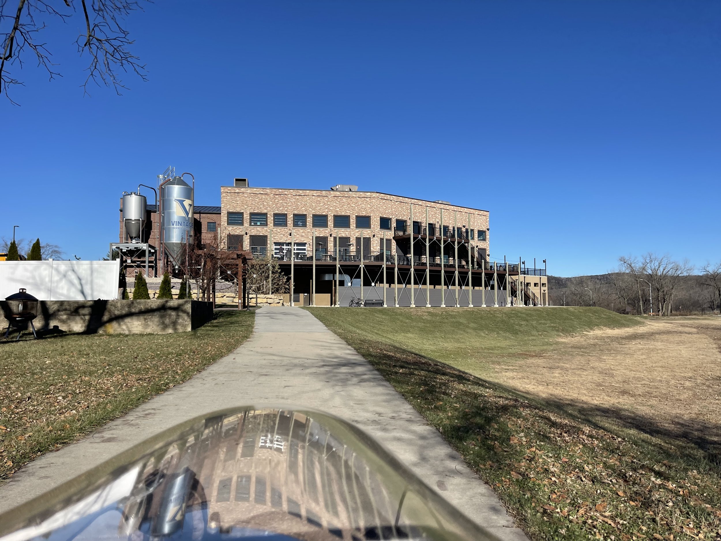
Vintage Brewing Company

Vintage Brewing Company
This is a local brewery and brew pub with only a couple of additional sites in Madison. I had actually never heard of it, but you have to love any restaurant that has a dog menu. I was just starting out my ride, so I made a mental reminder to check it out later.
Not far after Vintage you come across Sauk City Riverfront Park - complete with a playground and a canoe launch site:
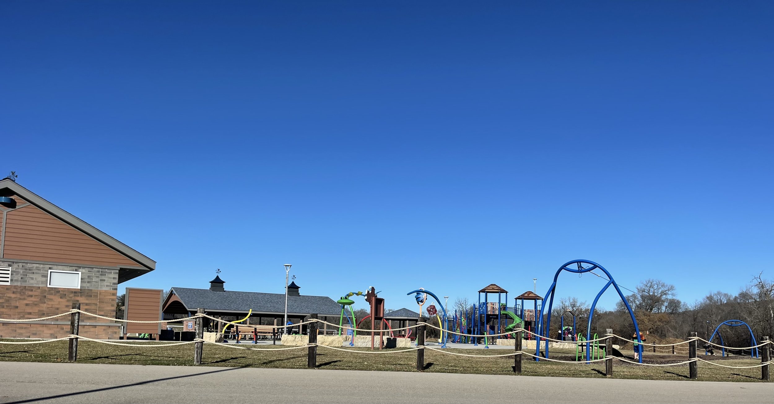
Playground

Canoe launch
You can go around this and stay on the main trail, which I did on the way back, but riding through the park gets you some views right on the river, and takes you through the trees and along a couple of delightful wooden bridges:

Let’s play Bridge!
And you quickly note that the trail is marked at half-mile increments with artistically rendered steel cut-out markers. There are a couple of different varieties:

Marker

Marker
There are a couple of other parks marked along the map as you are riding through the two towns, though they didn’t seem terribly well defined to me. The exception to that was Veteran’s Memorial Park, which was easy to distinguish:
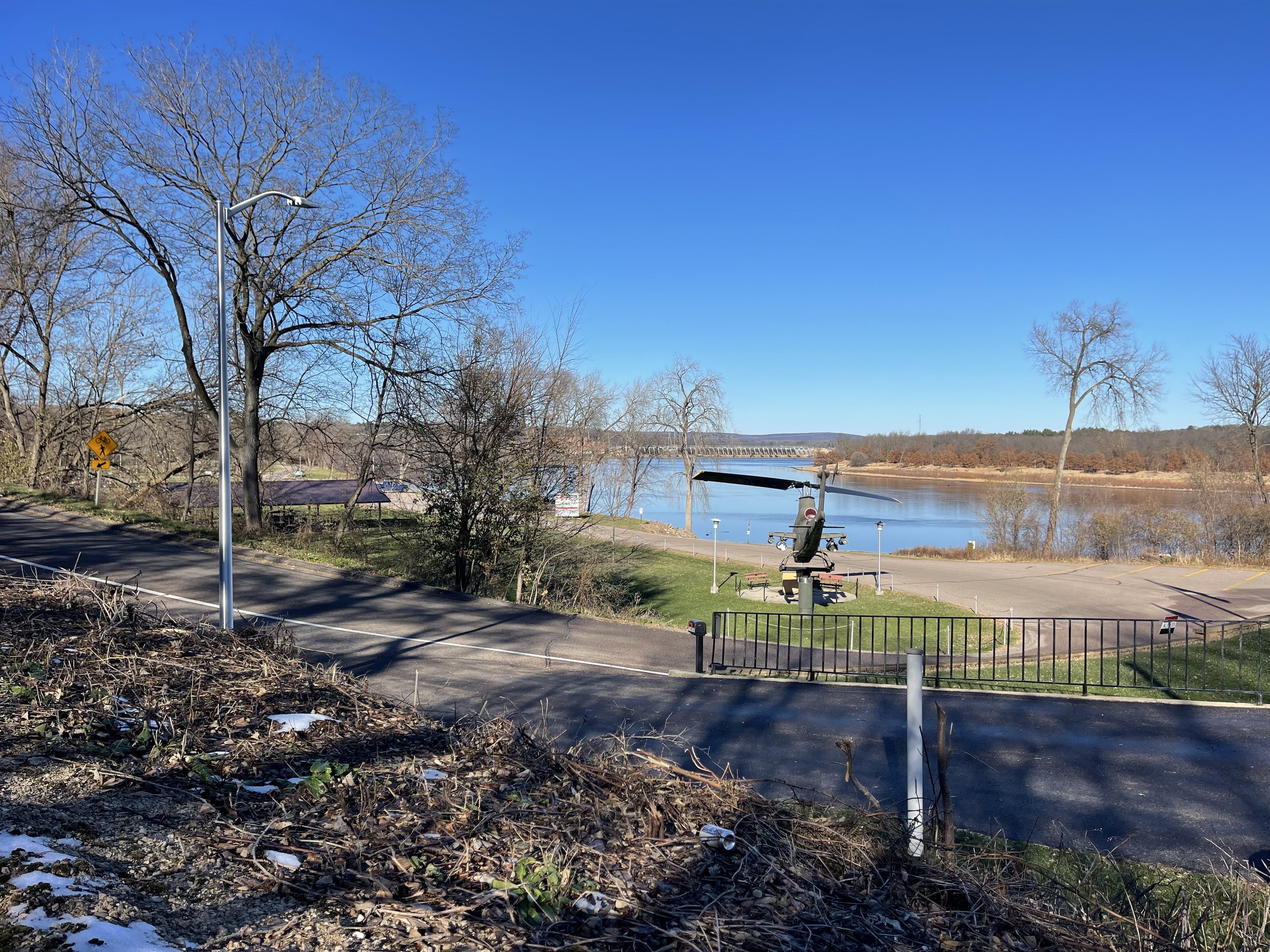
Helicopter and Dam
Beyond the helicopter you can see the dam that creates Lake Wisconsin above it. And down below the helicopter is a boat launch as well.
Veteran’s Memorial Park also marks the end of the town portion of the ride, moving you off into the trees, and beginning to arc away from the river. But there is one more chance to get up and close with the water if you take a brief side trip.
The Dam Road

Yup - that’s what they call it
I’ve seen this name for a road that leads up to and/or over a dam in multiple locations over the years, both in Illinois and Wisconsin. I can never decide if the person giving the name lacks imagination and is just being practical, or thinks it’s funny. Or possibly both.
In this case, taking a side-trip of a little over a quarter of a mile takes you down below the Prairie Du Sac Dam, and just about as up close and personal with it as you are likely to want to be.
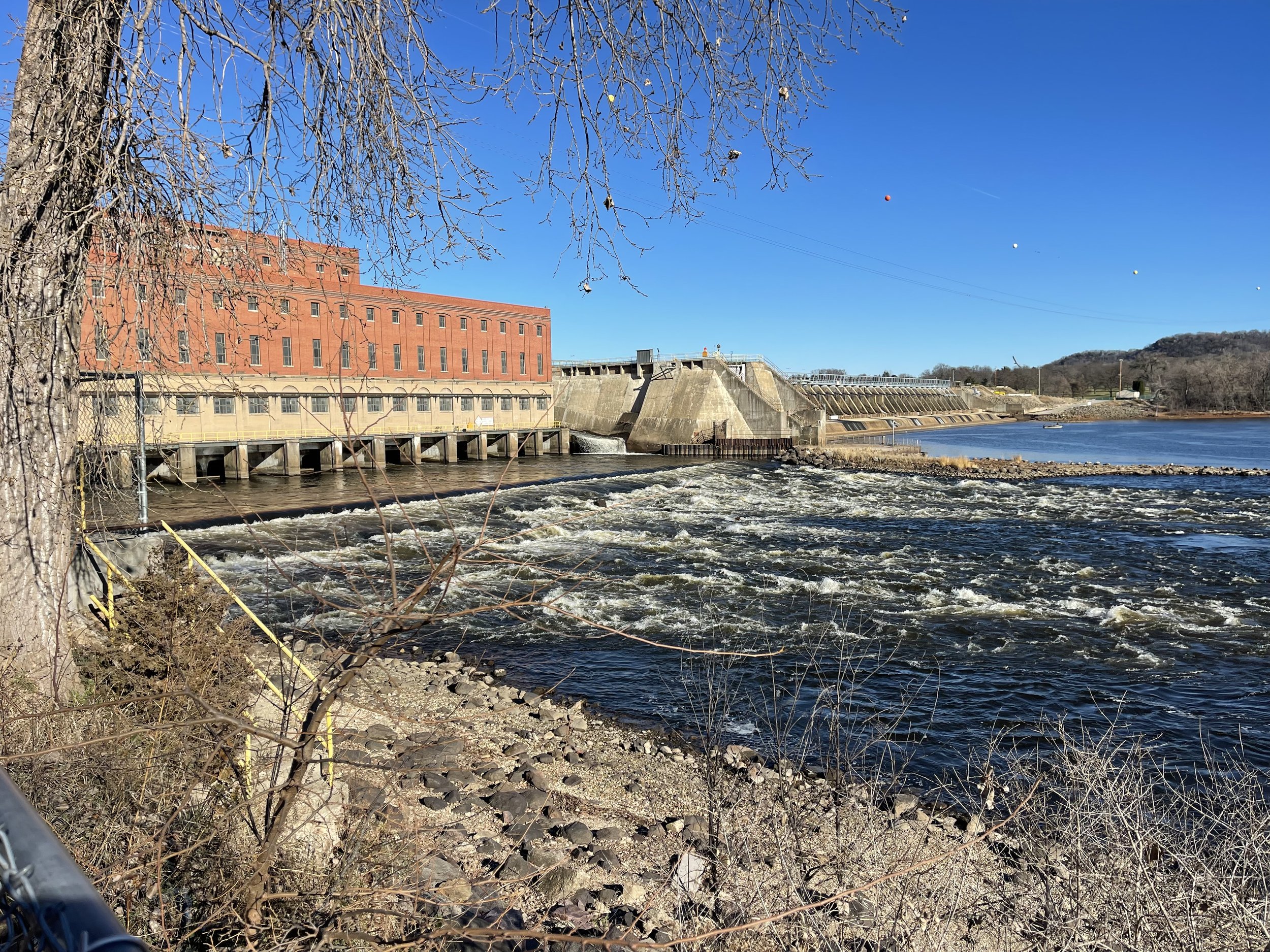
Prairie Du Sac Dam

Just below the dam
The area is heavy with waterfowl, and there is access to the shoreline for fishing as well. Between the wildlife, the water, and the sight and sounds of the dam itself, there’s a lot to take in, and I found myself hanging out here for a little while to do just that. My brother-in-law had suggested taking the side-trip to see it, and I’m glad I did. I’d likely have skipped it if he hadn’t mentioned it.
As a bonus, it’s a bit of a hill climb on the way out as well - not long, but enough to get your heart pumping relative to the rest of the trail.
The Badgerlands
Not far after the Badgerlands the trail crosses highway 78 - the only major road crossing after the beginning of the ride - and proceeds thru a bit of agricultural territory before coming to the entrance of The Badgerlands:

Badgerlands Sign as seen from the trail

Badgerlands Sign seen up close
This area - which is the final portion of the trail - takes the rider through land reclaimed from the Badger Army Ammunition Plant. The plant was decommissioned in 1997, and efforts have been made to reclaim and repurpose the land in multiple ways - most of it returning to natural territory. The effort is good, and while you can see the remnants of the plants roadways from a satellite view, from the trail you wouldn't notice it without the markers.

Trail informational markers
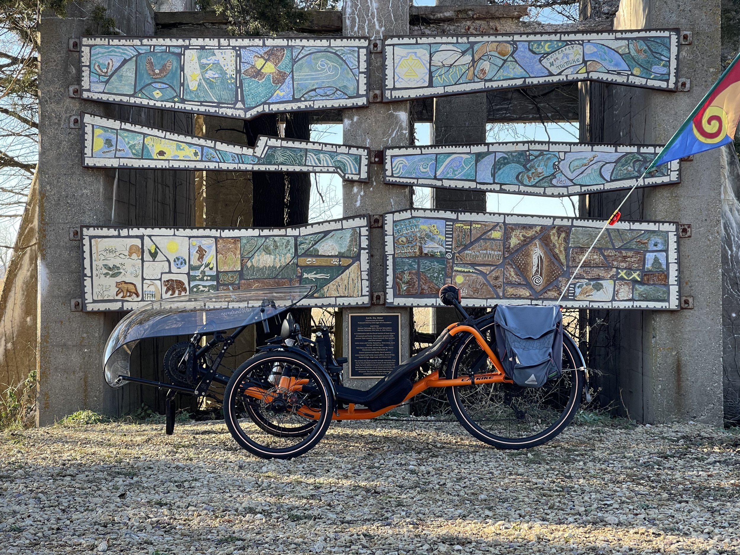
A part of the land was reclaimed by the Ho-Chunk Nation, and the trail runs along the eastern border of that section. Partway into this Territory you will come across a very colorful art installation, repurposing what look to me like cement pillars for a massive pipeline:

Earth, Sky, Water

Marker for Earth, Sky, Water
There are art pieces and installations all along the trail. They are nice to see, and detailed on the trail organization’s website. I realized after the fact that I saw most of them, but I may have missed a couple. I’ll have to look closer next time.
After the Earth, Sky, Water Piece the trail moves into the woods for the remaining mile and three-quarters or so. This would be the southern end or so of Devil’s Nose State Natural area to the north, and Devil’s lake beyond that. And that’s the view as you reach what is, undeniably, the end of the trail:
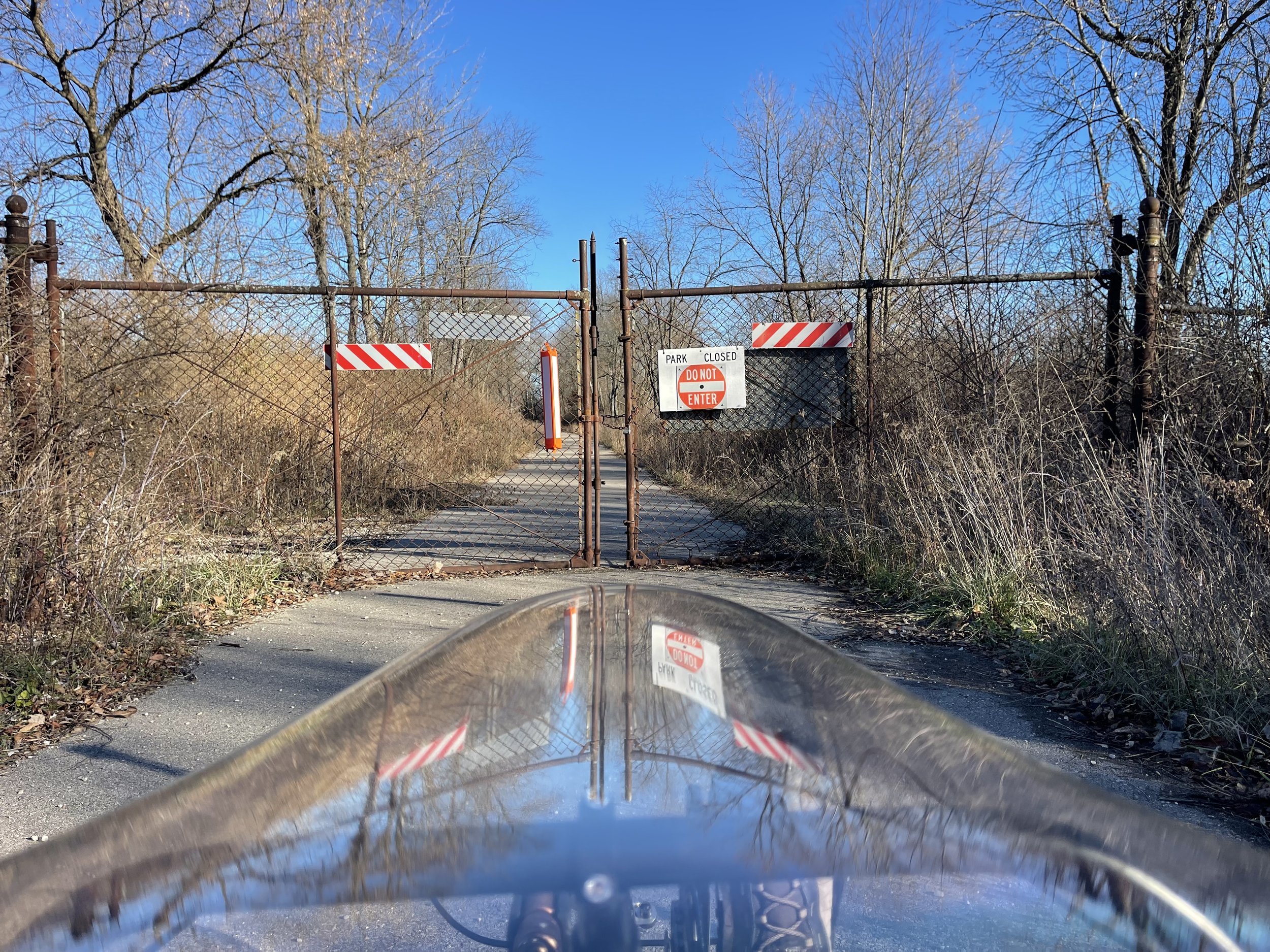
This far, and no further.
The maps show the trail continuing about another mile past the fence, and you can clearly see the asphalt, stretching tantalizingly beyond the fence. It’s not immediately clear why this is this case. It does appear to be the park boundary, and sometimes park areas in Wisconsin are marked off during hunting season (which was definitely in effect at this time). But the fence appears to have been in place in that position for some time, and you can see the growth to the sides encroaching on the asphalt.
I left the mystery for another day and turned around to head back.
The Return/Wrapping Up
Although the trail itself visually seems very flat visually, because it’s following the river course, you are technically climbing for most of the way up it, and descending most of the way back. It’s subtle, sometime just a few feet across a mile (and some miles come back on Cyclemeter as completely flat), but it resulted in higher speeds on my return than on the way out. This was enough of an effect that I was able to overtake the fat biker who had passed me just after turning around - and thanks to that gentleman for the compliment - “sweet ride” he said, as he passed me - another mile or two down the road, and to stay ahead of him for the rest of the ride.
The trail surface is beautiful throughout - as advertised, the entirety of it is paved, and it’s in excellent condition. I averaged 13.6 mph, which is right in my overall average for the month thus far, and well above the 8-9 mph I would typically see on the Military Ridge trail this time of year.
If you choose to try it out, it’s good to be aware that, while there are bathroom facilities on the trail, they largely end once you get out of the town. And, the ones that I tried were closed for the season, though my brother-in-law says that they have porta-potties at Veteran’s Memorial Park. For those willing to go more au natural for relief, be aware that there isn’t much coverage to the sides of the trail (and wandering into the woods during hunting season is generally inadvisable anyway).
The trail was fairly popular in town, even on a November day (though it was also unseasonably warm), but largely empty outside of town. I’d guess it’s busier overall on-season.
The course that I rode is actually a little different than what the trail website shows on their website. They have it starting further back into Sauk City, on city streets, and joining at Riverfront Park instead of following where I joined near the bridge. This is… odd, in that it puts the “trailhead” even further from the purported start of the trail. One wonders if the Chamber parking lot was just the best spot to give people to leave their cars. According to the map, I missed one of the art installations as a result of this. Again, maybe I’ll do it their way next time.
And that’s my second reference to next time, which is illustrative. This was a very nice ride, and I will plan to return to it. I’d like to get a chance to ride it in the spring or summer, or even earlier in the fall to enjoy the differences in scenery.
And also recommending it? The opportunity to pack up and end the day with a delightful locally brewed draft…

Butternut Road Brown Ale at Vintage Brewing Co
As a final aside, let me note that Vintage was one of the rare brewpubs I’ve been to that had an ESB (Extra Special Bitter) on their beer list. Unfortunately they were out during my visit, but the Butternut Road Brown Ale was also very nice. And - if you enjoy a bluegill basket, something hard to find anywhere but Wisconsin - they’ve got you covered!
Valencia and Earth, Sky, Water